Topiaries on a Tuesday
First a duh dumb moment from a stupid radio spot: "It's almost impossible to lose weight when you're hungry all the time." Excuse me? Wouldn't the more accurate statement be that it is almost impossible to lose weight if whenever you feel hungry you eat -- different thing entirely.
I'm a bit obsessed with weight and I'm annoyed that my body is not cooperating with my weight loss goals and seems to be immune to all my efforts but I've not fallen for the it's not your fault or effortless results camp that this and other ads are clearly targeting.
Onto the topiaries. My walkabout routes had been getting a bit stale/predictable so I've been mixing it up a bit by exploring old treks and discovering new ones. On Saturday, I decided to take some new Havianas to the streets. I logged about six miles or so on them, rediscovered the house that is the subject of today's post and also took in a couple of street/stairs.
Without the start from my place bit, here's the route: Starting at University & 5th (aka at the Hillcrest sign) go West on University to Goldfinch. South on Goldfinch to Bush, West on Bush, Bush becomes Wellbourn.
 Continuing on Wellbourn, there are viewpoints on the North end of Neale and Torrance.
 The one at Neale appears to be public parking and the one at Torrance seems to be part of a deck for a private home.
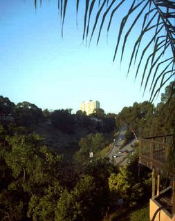
This is from the Neale viewpoint facing Northeast with the Washington Street hill and the University turn off.
The sun was preparing to set as I walked along which made for a better view but not so great photos whenever I was facing West.
The view at the end of Wellbourn is also pretty inspiring and worth a stop and reflect moment as you look over San Diego bay, the airport and the city's skyline.
The right side of the road's vine covered fence frames the scenic view as you move South on Torrance. The street then widens to a palm lined avenue before intersecting with Kite. West on Kite, North on Puterbaugh, West on Lark.
Lark in this area is an interesting street. After a few yards, only the left (South) side of the street appear to have houses. The right (North) side seems to consist of a guard rail and wall. This segment of the street seems to end about a block past the intersection of W. Walnut where a chain link fence surrounds a construction site.
But this bit of Lark has a surprise twist. If you walk down the Northern side of the street, and peer over the wall you'll see a series of houses on what seems to be another unknown road/street.
Just past the the intersection of W. Walnut the wall is interrupted with a set of stairs leading down to that road. Here's the twist, to the right of the construction site, just when you thought the street ends, the pavement makes a U turn to the North. If you follow the road round to the right, and read the street numbers, it becomes apparent that this bit of Lark is a street divided by elevation and bridged by a set of stairs.
On the day I was on walkabout, I spotted two women walking their dogs by the dirt track at the South West side of construction. It wasn't clear to me whether the dirt track is part of a public walkway or whether the women had taken a short cut through driveways and other private property. That exploration is for another day.
After solving the mystery of the Lark Street Stairs, walk up the stairs and proceed South on W. Walnut.
 Turn West on Kite and go North on Union. Approaching Vine, the hill of topiary comes into view on the Eastern (right) side of the street.
 I don't know the back story, the who, why or even how but I am delighted that the topiaries are still there and being maintained. I happened upon them many years back during one of my ramble abouts the neighbourhood and, until last Saturday, I couldn't recall where they were.
 While the topiaries are an extreme example of houses with character, there are other houses, stairs, bridges, weird shrubs and the like in the older neighbourhoods of San Diego that boost the charm factor of the area by being a bit quirky.
North on Union to Glenwood. Follow Glenwood West round to India. India North to Washington. Cross Washington and continue past Palomar Market and go up the India Street stairs to the intersection of India, McKee, Keating & Titus.
 As I stopped to take a shot of the stairs. the security guard in the parking lot and I had a bit of a chuckle/chat about what I was after a shot of. I told him that while he was quite charming, my interest was in the stairs and no, I did not want to see me in the picture.
North on Titus, East on Pringle. As you pass Guy, although some of the lot has given way to houses, the South (right) side of Pringle still offers a spectacular view of the city skyline and the bay. People pay big bucks for houses with that view so take a moment to take a breather and admire the view. This location is a great place to take in the fireworks on the 4th of July.
I was losing light as I crested the Pringle Street hill so I opted to head North on Washington Place rather that continue on East on Pringle and take the stairs to Pioneer Park. Washington Place becomes Washington at Goldfinch.
At the Southeast corner of Washington and Goldfinch, you'll find The Gathering (still boarded up after a fire swept through it). A few yards North is the decadent delight that is Phil's BBQ.
The building on the Northeast corner of the intersection used to house a number of shops and the Mission Hills Cafe. It is now mostly vacant and targeted for some sort of renewal project.
Without getting into that whole can of worms, I noticed that the original brick facade was peeking through a section on the Goldfinch elevation. That section, made the remains of the later "modern" facing look a bit like a cardboard box had been dropped over the building. The original brick is interesting. The modern, which is now more retro than modern, is more familiar and the fate of the building is probably in the hands of an architect and/or a committee or two.
On the Southwest side of Washington there's the Mission Hills branch of the library, the new location for M-Theory records and a florist shop.
Cross Washington at Goldfinch. Go East on Washington to 5th, South one block on 5th to the starting point of University & 5th.
According to the route tracker at gmap pedometer.com
which is a pretty nifty tool even if it's maps aren't totally accurate the mileage on this walk is approximately 4.13 miles from start to finish.
So a walkabout ramble and a bit of a rant. Next time lots of knitting content.
I'm a bit obsessed with weight and I'm annoyed that my body is not cooperating with my weight loss goals and seems to be immune to all my efforts but I've not fallen for the it's not your fault or effortless results camp that this and other ads are clearly targeting.
Onto the topiaries. My walkabout routes had been getting a bit stale/predictable so I've been mixing it up a bit by exploring old treks and discovering new ones. On Saturday, I decided to take some new Havianas to the streets. I logged about six miles or so on them, rediscovered the house that is the subject of today's post and also took in a couple of street/stairs.
Without the start from my place bit, here's the route: Starting at University & 5th (aka at the Hillcrest sign) go West on University to Goldfinch. South on Goldfinch to Bush, West on Bush, Bush becomes Wellbourn.
 Continuing on Wellbourn, there are viewpoints on the North end of Neale and Torrance.
 The one at Neale appears to be public parking and the one at Torrance seems to be part of a deck for a private home.
This is from the Neale viewpoint facing Northeast with the Washington Street hill and the University turn off.
The sun was preparing to set as I walked along which made for a better view but not so great photos whenever I was facing West.
The view at the end of Wellbourn is also pretty inspiring and worth a stop and reflect moment as you look over San Diego bay, the airport and the city's skyline.
The right side of the road's vine covered fence frames the scenic view as you move South on Torrance. The street then widens to a palm lined avenue before intersecting with Kite. West on Kite, North on Puterbaugh, West on Lark.
Lark in this area is an interesting street. After a few yards, only the left (South) side of the street appear to have houses. The right (North) side seems to consist of a guard rail and wall. This segment of the street seems to end about a block past the intersection of W. Walnut where a chain link fence surrounds a construction site.
But this bit of Lark has a surprise twist. If you walk down the Northern side of the street, and peer over the wall you'll see a series of houses on what seems to be another unknown road/street.
Just past the the intersection of W. Walnut the wall is interrupted with a set of stairs leading down to that road. Here's the twist, to the right of the construction site, just when you thought the street ends, the pavement makes a U turn to the North. If you follow the road round to the right, and read the street numbers, it becomes apparent that this bit of Lark is a street divided by elevation and bridged by a set of stairs.
On the day I was on walkabout, I spotted two women walking their dogs by the dirt track at the South West side of construction. It wasn't clear to me whether the dirt track is part of a public walkway or whether the women had taken a short cut through driveways and other private property. That exploration is for another day.
After solving the mystery of the Lark Street Stairs, walk up the stairs and proceed South on W. Walnut.
 Turn West on Kite and go North on Union. Approaching Vine, the hill of topiary comes into view on the Eastern (right) side of the street.
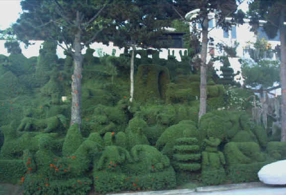 I don't know the back story, the who, why or even how but I am delighted that the topiaries are still there and being maintained. I happened upon them many years back during one of my ramble abouts the neighbourhood and, until last Saturday, I couldn't recall where they were.
 While the topiaries are an extreme example of houses with character, there are other houses, stairs, bridges, weird shrubs and the like in the older neighbourhoods of San Diego that boost the charm factor of the area by being a bit quirky.
North on Union to Glenwood. Follow Glenwood West round to India. India North to Washington. Cross Washington and continue past Palomar Market and go up the India Street stairs to the intersection of India, McKee, Keating & Titus.
 As I stopped to take a shot of the stairs. the security guard in the parking lot and I had a bit of a chuckle/chat about what I was after a shot of. I told him that while he was quite charming, my interest was in the stairs and no, I did not want to see me in the picture.
North on Titus, East on Pringle. As you pass Guy, although some of the lot has given way to houses, the South (right) side of Pringle still offers a spectacular view of the city skyline and the bay. People pay big bucks for houses with that view so take a moment to take a breather and admire the view. This location is a great place to take in the fireworks on the 4th of July.
I was losing light as I crested the Pringle Street hill so I opted to head North on Washington Place rather that continue on East on Pringle and take the stairs to Pioneer Park. Washington Place becomes Washington at Goldfinch.
At the Southeast corner of Washington and Goldfinch, you'll find The Gathering (still boarded up after a fire swept through it). A few yards North is the decadent delight that is Phil's BBQ.
The building on the Northeast corner of the intersection used to house a number of shops and the Mission Hills Cafe. It is now mostly vacant and targeted for some sort of renewal project.
Without getting into that whole can of worms, I noticed that the original brick facade was peeking through a section on the Goldfinch elevation. That section, made the remains of the later "modern" facing look a bit like a cardboard box had been dropped over the building. The original brick is interesting. The modern, which is now more retro than modern, is more familiar and the fate of the building is probably in the hands of an architect and/or a committee or two.
On the Southwest side of Washington there's the Mission Hills branch of the library, the new location for M-Theory records and a florist shop.
Cross Washington at Goldfinch. Go East on Washington to 5th, South one block on 5th to the starting point of University & 5th.
According to the route tracker at gmap pedometer.com
which is a pretty nifty tool even if it's maps aren't totally accurate the mileage on this walk is approximately 4.13 miles from start to finish.
So a walkabout ramble and a bit of a rant. Next time lots of knitting content.
posted by walkaboutknitter at
21:11
![]()


0 Comments:
Post a Comment
Subscribe to Post Comments [Atom]
<< Home